|
|
|
|
Paolo Angeli Personal Website |
Celestia Feature requests: Group 2 FR5 Ground locations |
|
A complete management system for ground locations. Is requested the capability of defining ground locations on bodies, like cities, observatories, landing sites, craters, volcanoes etc.
Description: Te capability of defining ground locations on body surfaces is something that I’ve suggested in the Celestia Users Forum about one year ago, immediately after I’ve met this wonderful software. With ground locations will be possible to display the most representative and interesting locations from different point of view:
These locations must be selectable in some manner by the user. So should be possible for the user to place the Celestia observer with a simple goto (location) command. A lot of nice things could be done with this feature. Some examples. You will be able to:
The ground locations could be defined specifying in an appropriate structure in SSC file:
The name The longitude; The latitude; The size; The type;
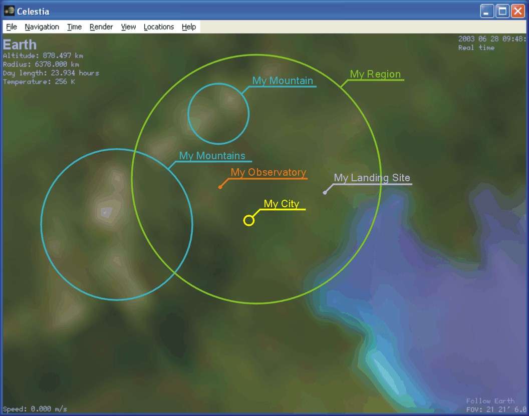
The name should be used for the label visualized for the location. The size should be useful to give to the location a weight that should be used to define some kind of sorting. The type should be useful to categorize the locations and so for the implementation of a selective visualization. The locations could be represented by a colored circle placed on the surface accordingly with latitude and longitude coordinates. The diameter of this circle should be proportional to the size of the location. Near this circle could be displayed the label. The color of the circle and of the label could be defined by the type of the location. See the following figure:
The SSC file format allows to build hierarchies of objects/entities. Some kind of hierarchy for locations should be advisable too. The hierarchy should be useful to help the sorting process in the situations where is advisable to reduce the number of displayed locations. Specially in areas where there is a high concentration of locations, to avoid overlapping of circles and labels when the observer is far. To avoid the chaos and to preserve the CPU elaboration time resource, specially when the community will make available a lot of ADD-ON locations for all the bodies of solar and non solar systems, some kind of UI management must implemented. So at least something like the actual capabilities in ver. 1.3.0 of displaying selectively labels for stars, planets, moons, probes etc. must be implemented. Furthermore should be advisable to implement something that could allow the user to enable/disable the locations management.
Required/Suggested: (...)
Further related improvements:
Related Newsgroup Threads: (...)
Reference Celestia Version: 1.3.0
Status: (28-06-03) Submitted to the forum attention. (28-06-03) Under development.
Subscribers (Subscribe this item) Paolo Angeli, John J. Szucs.
Back
to
Group 2.
|
|